
The 1st Congress in Geomatics Engineering aims to bring together scientists, academics and PhD students to exchange and share their results of research and innovation related to any Geomatics discipline. It offers a first-class interdisciplinary platform to present and discuss the innovations, trends, concerns, challenges and solutions adopted in the different fields of Geomatics.
This biennial Congress is born within the framework provided by the Interuniversity PhD program in Geomatics Engineering by the Universidad Politécnica de Valencia and the Universidad Politécnica de Madrid.
All participants should prepare their work as articles of 5 to 10 pages following the format that is detailed in the following link (download template), where they can present the progress of their research and the obtained results. These articles will be freely available on the congress website and will be protected with the corresponding ISBN (for the proceedings book that will contain the articles) and doi for each particular contribution.
For those contributions not selected for an oral presentation during the congress, there will be a chance to present a poster (vertical DINA0).
Thus, each of the contributions must deliver the corresponding article and, on a voluntary basis, the corresponding presentation (oral or poster), which will also be posted on the congress website.
It is mandatory to send the authorization of rights with the original signature OF EACH OF THE AUTHORS as a complementary material in the submission process.
Any scientific work related to Geomatics Engineering can be presented at the congress. In particular, research related to any of the thematic areas of the PhD programme will be adequate:
Important Dates
The registration and access to the platform for manuscript submission will start on 1 March, 2017.
The articles should be sent before May 15, 2017 in the correct format. Only those articles that meet the requirements will be eligible for inclusion in the proceedings book.
Fees
PhD Students undertaken a Doctoral Programme, 35 euros.
Other attendees, 60 euros.
This price includes the coffee breaks and lunch on the 5th. Each contribution will require, at least, one of the participants to be registered before June 1, 2017.
Cancellation Policy: 100% until June 1st and 50% as of June 1st.
Programme
You can download the full programme here
You can download the CONFERENCE PAPERS BOOK here
| Wednesday 5th of July | |
|---|---|
| 08:30-09:30 | REGISTRATION |
| 09:30-10:00 |
CONGRESS OPENING: Jorge Padín, Jesús Velasco, Ana B. Anquela, Xavier Navarro, Amparo Chiralt |
| 10:00-10:45 |
OPENING KEYNOTE: Ismael Colomina |
| 10:45-11:15 | COFFEE BREAK |
| 11:15-13:30 | SESSION 1 |
| 13:30-14:30 | LUNCH BREAK |
| 15:00-15:45 |
INVITED KEYNOTE: Belén Benito |
| 15:45-17:15 | SESSION 2 |
| 17:15-17:45 | COFFEE BREAK |
| 17:45-19:30 | SESSION 3 |
| Thursday 6th of July | |
|---|---|
| 09:00-09:45 |
INVITED KEYNOTE: Antonio Ruiz |
| 09:45-11:15 | SESSION 4 |
| 11:15-11:45 | COFFEE BREAK |
| 11:45-13:15 | SESSION 5 |
| 13:15-13:30 |
CLOSING REMARKS: Jorge Padín, Jesús Velasco, José Luís Lerma, Belén Benito |
The Mapping international Journal covers this first meeting that aims to create an important forum for discussion and debate on the profession led by bloggers who write about different areas of Geomatics. These bloggers are a great connoisseur of the reality and its actuality, fundamental aspect to write their articles and to be in contact and maintain their followers. This is the reason why they can be an interesting source to take the pulse to the current activity of the profession ( Advances, forms of work, market niches, etc.). As a conclusion to the meeting, an attempt will be made to give ideas about where GEO world and environment are going, and the conclusions will be publisheded in the Mapping journal, in its blogs and / or social platforms.
Bloggers who write with a certain periodicity articles about the GEO environment in their blogs will be invited. The meeting is aimed at all those people who are interested in this subject, mainly to all those who altruistically have a blog with editorial line of Geomatics, such as surveyors, agronomists, geographers, etc.
The meeting place will be the meeting room or the hall of degrees (depending on the attendance) on July 5 at 12:00 hours.
Keynote Speakers
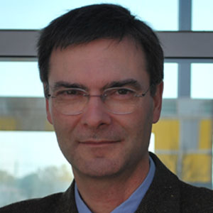
Ismael Colomina Folch is, since 2015, Chief Scientist in Geonumerics company. Colomina was the Head of Geomatics of the Centre Tecnològic de Comunicacions de Catalunya (CTTC, Castelldefels, Spain) since the beginning of 2014. Prior to that, between 1998 and 2013, he was the Director of the Institute of Geomatics (IG) and the Head of Geodesy of the Institute of Cartography of Catalonia (ICC) where he worked from 1982 to 1998.
Dr. Colomina is an international expert in INS/GNSS navigation and post-mission trajectory determination for geodesy, photogrammetry and remote sensing applications. He is also an expert in sensor orientation and calibration. He belongs to the group of geomaticians that pioneered the use of unmanned aircraft in photogrammetry and remote sensing.
Since 1992, Colomina has served as chair and co-chair of ISPRS Working Groups (WGs) and currently of the WG III/I ""Sensor Modelling for Integrated Orientation and Navigation.” He also served as President of EuroSDR's Commission I “Sensors, primary data acquisition and georeferencing" from 2002 to 2006.
Services and products with high technological added value are highly demanded in our society. In geomatics and navigation fileds, this demand is satisfied both from the public and private sector. Infrastructures are a good example for public sector (GNSS or geo-information), and, following with those examples, most of the products that support and exploit these infrastructures are under private responsibility. Both sustained by the professionals and the scientific knowledge generated in Universities and research centers.
In this context of technological complexity and connectivity, research and development is not an activity confined to University and research centers. In particular, the future professionals options for young doctoral students are several, all of them technically demanding and highly stimulating. Dr. Ismael Colomina, director of GeoNumerics company, will present his vision and experience about this topic, the company and research projects, providing information to the students about the geomatic growing professional profile.
YOU CAN DOWNLOAD THE SPEAK IN PDF FORMAT HERE
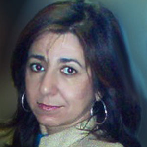
Belén Oterino is the Director of the Research Group in Seismic Engineering at the Polytechnic University of Madrid, where she is a professor.
Her professional experience includes: Seismic monitoring of critical installations (Nuclear Safety Council, CSN and National Company of Radioactive Waste, ENRESA). Seismic hazard studies for the revision and definition of Spanish seismic standards (NCSE-94 and NCSE-02). Consultancy for the definition of seismic action in special installations, such as nuclear power plants, dams, bridges, industrial plants and ITER. Seismic Risk research direction for the emergency plans definition in the regions of Andalusia, Navarra and Murcia. Cooperation research direction in subjects of seismic threat in Central America and Caribbean.
She has been principal researcher in 25 publicly funded research projects and has more than 70 publications in scientific journals.
In the analysis and management of seismic risk, as well as other natural hazards, modern geospatial technologies play an important role. The estimation of risk entails the development of different phases designed to: 1) Characterize the expected movement of future earthquakes by calculating the seismic hazard, 2) Establish the distribution of vulnerability classes according to the construction typologies of the study area, and 3) Estimate the expected damage to infrastructures, as well as its social and economic impact. All these phases are currently addressed using the Geographic Information Systems (GIS), which are an essential tool in any risk study. Other geospatial technologies are remote sensing, used to characterize the vulnerability of a region, as well as rapid assessments of damages evaluation by comparing images before and after the event, or the use of GNSS measurements that contribute to geodynamics knowledge and current stress state characterization of a particular zone or fault system. All this provides relevant information to the knowledge of the seismic cycle, which is of vital importance in the "prediction" of earthquakes. Likewise, GNSS allows to determine the co-seismic displacement caused by an earthquake, where Radar Interferometry (INSAR) technique can be used too.
This lecture will present an overview of the geospatial technologies role in the field of seismic risk and will present real examples based on recent earthquakes, including important lessons learned from them, keeping in mind the establishment of measures to mitigate seismic risk.
YOU CAN DOWNLOAD THE SPEAK IN PDF FORMAT HERE
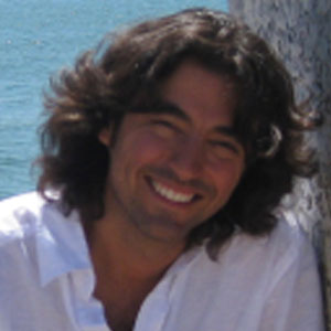
Antonio Ruiz-Verdú has a long experience in the remote sensing of biophysical parameters. Since 2013, he is research assistant in the Laboratory for Earth Observation (LEO) at IPL-UVEG. He worked previously in Spanish Government Agencies for Space research (INTA; 2008-2012) and hydrological and ecological applied research (CEDEX; 1996-2007) in which he participated in national-funded studies for crop mapping, detection of irrigated areas and estimation of water needs for agriculture. He has participated in ESA-funded projects (SPARC, SEN2FLEX, SEN3EXP) for the preparation of new EO missions and the validation of algorithms for the retrieval of biophysical parameters.
The speaker will present the new possibilities of free access to Earth observation satellite missions data. In particular, those from the European Copernicus program, as well as the main financing sources for research projects based on the use of such data. As outstanding examples of potential applications, he will review the projects carried out by the Earth Observation Laboratory of the University of Valencia. These projects are related to vegetation dynamics, water quality and applications in agriculture.
YOU CAN DOWNLOAD THE SPEAK IN PDF FORMAT HERE
Sponsors


Collaborators


About Valencia
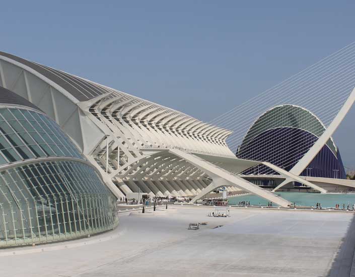
Valencia is a dynamic city, full of culture. Valencia is the third largest city in Spain. It was founded by the Romans and lies on the banks of the river Turia, on the east coast of the Iberian Peninsula, on the Mediterranean Sea. Its rich historic centre is one of the largest in Spain. Major historical monuments include the Llotja de la Seda (a UNESCO World Heritage Site), the Cathedral of Valencia, two towers (Torres de Serranos and Torres de Quart), and the Ciutat de les Arts i les Ciències (City of Arts and Sciences). There are many museums and art galleries. Well recommended are the Institut Valencià d'Art Modern (Valencian Institute of Modern Art) and the Museu de Belles Arts.
For more information about Valencia, please visit:

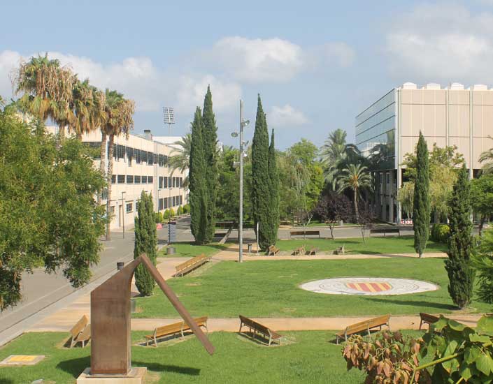

The Universitat Politècnica de València (UPV), Vera Campus, is found close to the beach, just outside of the main city centre.
The conference itself will take place in building 7I and 6G, which can be found on the map of the Vera Campus.
Valencia is the third largest city in Spain, and therefore is easily access by air transport, both low-cost and regular airlines. The airport is well connected to the main city (underground, bus, taxi...), and travellers will have no problem getting to and from Valencia using air transport.
Valencia has both normal and high-speed train lines, and with only 1.5 hours between Valencia and Madrid, it is easily accessible by high-speed train (AVE), allowing travellers to also access to the city through the country's capital.
Valencia is on the main transport networks in Spain, and is easily accessed by car.
| Hotel Silken 4* | http://www.hoteles-silken.com/destinos/valencia |
| Hotel Barceló 4* | https://www.barcelo.com/barcelohotels/es_es/hoteles/espana/valencia/hotel-barcelo-valencia/descripcion-general.aspx |
| Hotel NH Ciudad de Valencia 3* | http://www.nh-hoteles.es/hotel/nh-ciudad-de-valencia?dclid=CPSwra3uq8oCFcubFgodKakKOA |
| Hotel Universidades 3* | http://www.hoteluniversidades.com |
| Student Resident Galileo Galilei | http://www.galileogalilei.com |
| Student Resident Damia Bonet | http://www.resa.es/es |
Information for Foreigners Please make sure you have met all the requirements for entry into Spain if you are not a citizen of the European Union.